GeoScan’s Multichannel Analysis of Surface Waves (MASW) service is a non-invasive geophysical method used to assess the stiffness of subsurface materials and delineate bedrock depth with high accuracy. This technique provides valuable insight for construction, geotechnical, and environmental projects by analyzing the propagation of surface waves to determine the shear wave velocity profile of the ground.
Why Use MASW?
MASW is an ideal solution for projects that require a detailed understanding of subsurface stiffness and bedrock characteristics. Unlike traditional invasive methods, MASW offers a cost-effective and efficient way to gather geotechnical data and can serve as a valuable complement to drilling programs by enhancing desktop studies and aiding in design and planning decisions.
Key benefits of MASW include:
- Accurate Bedrock Detection – Identify the depth and contours of bedrock, crucial for foundation design, excavation planning, and geological studies.
- Subsurface Stiffness Profiling – Measure variations in stiffness across different soil and rock layers, helping engineers assess ground stability.
- Complimentary to Drilling – MASW enhances borehole data, increasing spatial coverage and providing additional insight for geotechnical investigations.
- Supports Engineering & Construction Planning – Provides critical data for roadways, bridges, high-rise buildings, and other infrastructure projects.
How MASW Works
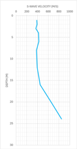
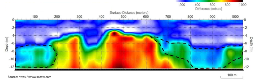
MASW measures the velocity of surface waves generated by a seismic source, such as a hammer strike or controlled vibration. These waves travel through the subsurface, with their speed influenced by the material stiffness. By deploying multiple geophones along the surface, GeoScan captures the waveforms and processes them to develop a shear wave velocity profile, revealing the subsurface structure and bedrock depth.
1D & 2D MASW Deliverables
GeoScan provides flexible MASW survey deliverables to meet a variety of project needs:
1D MASW – Point-type sampling, ideal for obtaining stiffness information at discrete locations.
2D MASW – Continuous profiling along a survey line, useful for mapping variations in subsurface stiffness and bedrock topography.
Applications of MASW
MASW is widely used in various industries and project types, including:
- Bedrock Surveys – Accurately locate and map the depth of bedrock for foundation and excavation planning.
- Geotechnical Investigations – Assess soil stiffness and layering for construction and infrastructure projects.
- Slope Stability & Landslide Risk Assessment – Determine subsurface stiffness variations that impact slope stability.
Why Choose GeoScan?
At GeoScan, we leverage state-of-the-art MASW technology to deliver high-resolution geophysical data tailored to your project’s needs. With our expertise and commitment to precision, we help engineers, developers, and geoscientists make informed decisions based on reliable subsurface insights.
Need a subsurface stiffness or bedrock survey? Contact GeoScan today to discuss how MASW and our other geophysical services can benefit your project.